
Morgan Memories – View of Morgan Beach Area, Circa Late 1920s
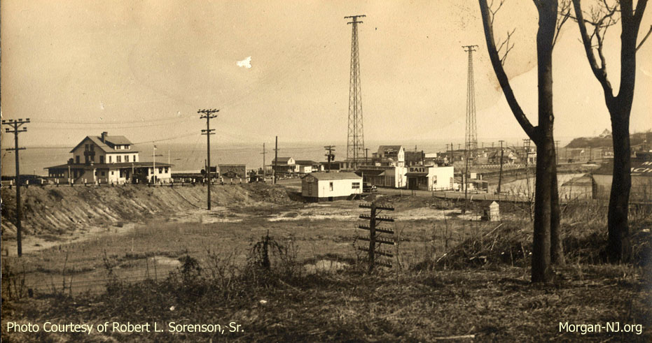
Morgan Beach Area Taken from Morgan Heights Circa Late 1920s Featuring Cady’s House of Seafood and Lockwood’s Bait Store. Photo Courtesy of Robert L. Sorenson, Sr.
This text accompanying the above image is still a work in progress. I just received this photo from my long time ago Morgan neighbor, Pam, and wanted to post it right away. I’ll finish this write up at a later time so please check back.
Firstly, let me give Pam a HUGE thank you for this amazing photo provided by (taken by?) her father, Robert L. Sorenson, Sr. I’m told it is circa the 1920s. Based on what I know about this specific area, it is no earlier than mid 1926 as that is when Cady’s House of Seafood (the big white building on the left) opened. The road in front of Cady’s opened in July the year before. Depending on when this photo actually was taken, this road was either designated at State Highway Route 4 or, sometime after 1927 (I think) State Highway Route 35. Before this incline was filled in with dirt, the Jersey Central Traction Company had their trestle in this spot. Based on the growth of brush and the erosion on the incline, the incline had been there for a few years.
On the far right we see the Henry Luhrs’ Morgan Yacht Basin (subject of a future page). Between them is the Morgan Fishery Restaurant and Lockwood’s Bait. Two of my great grandfathers used to sell bait to Mr. Lockwood during the summer according to my Mother.
Paul, Pam’s neighbor, saw the word “Golf” on the building in front of Lockwood’s Bait store and wrote, “Why would there be a golf shop there? Answer: Up until 1928 there was a 400 acre shore front golf and country club in Lawrence Harbor. Clark Gable, Guy Lombardo, the Prince of Wales and the Vanderbilts played golf and partied there. I could be wrong, but, it seems to make perfect sense to have a golf shop near a prominent golf course. What’s amazing is the amount of real estate on the opposite side of the creek. Could you imagine if Hurricane Sandy had hit this area back then? There’d be nothing left down there.” Alycia – please chime in here as you are the expert on Laurence Harbor. This perhaps could give us a clue about when the photo might have been, i.e., no later than 1928.
You can’t see the bridge over Cheesequake Creek because it was the predecessor bridge to the current Route 35 Bridge and was a double leaf bascule draw bridge which, by its nature, was not very tall. You can see an image of it if you click here. That bridge was replaced in the early 1940s by the current bridge so this photo was taken sometime after 1926 and before 1941-ish.
You can see some of the bungalows on Morgan Beach starting with Hock’s bungalow to the right of the Cady’s sign. Someday I’ll write that page about the Morgan Beach Bungalows.
Compare the above image to this one from about 1910, also taken from what was then known as Morgan Heights.
Awesome!

